The History of Lake Travis, From River to Reservoir
Before the dam there was a winding Colorado River canyon of farms and fords. This is how Mansfield Dam made Lake Travis, what the water covered, and how the lake has swung between flood and drought since 1942.
- Covers
- 1937 to today
- Length
- 8 chapters, 14 min read
- Published
Lake levels since 1942
The lake at every level since October 1942
The line traces the lake’s average level in feet, month by month once the full record loads, and the shaded band runs from each period’s low to its high. The figures come from LCRA’s Lake Travis workbook. Scrub to any point to read its average, low and high.
669.5ft2026, Jan to Aug
Low to high that year: 663.1 ft to 685.0 ft
Show the numbers by decade
| Decade | Lowest month | Highest month | Average |
|---|---|---|---|
| 1940s | 632.9 ft, Jun 1948 | 691.2 ft, Oct 1942 | 661.4 ft |
| 1950s | 614.2 ft, Aug 1951 | 707.4 ft, May 1957 | 662.8 ft |
| 1960s | 615.0 ft, Nov 1963 | 692.1 ft, Jan 1968 | 665.7 ft |
| 1970s | 645.8 ft, Jul 1978 | 692.4 ft, Apr 1977 | 675.6 ft |
| 1980s | 636.6 ft, Oct 1984 | 693.5 ft, Jun 1987 | 672.0 ft |
| 1990s | 651.8 ft, Aug 1996 | 710.4 ft, Dec 1991 | 674.4 ft |
| 2000s | 629.7 ft, Oct 2009 | 701.5 ft, Jul 2007 | 668.7 ft |
| 2010s | 618.6 ft, Sep 2013 | 704.4 ft, Oct 2018 | 656.3 ft |
| 2020s | 626.9 ft, Oct 2023 | 685.0 ft, Jul 2026 | 652.6 ft |
01/The river valley
The Colorado River Before Lake Travis Existed
Before 1937
For thousands of years people hunted, farmed and crossed the Colorado where Lake Travis now spreads. The valley held farms, a mill and river fords, not open water.
Before 1937
West of Austin the Texas Colorado River cuts through the eastern Edwards Plateau and Hill Country, then crosses the Balcones Escarpment at the city. The Handbook of Texas traces hunting and gathering in Travis County back about 10,000 years, and names Tonkawa, Lipan Apache, Comanche and Kiowa peoples in the county’s later record. That history belongs to the wider valley. It does not place every group at Marshall Ford, and a prehistoric burial found on a Travis shoreline in 2006 shows early occupation without proving a submerged Indigenous town.
By the 1800s the future lakebed was a working rural landscape. Wiley Hudson settled Hudson Bend in 1854, and the bend grew farms, ranches, a school and a church tied together by river fords. Around 1861 Thomas Anderson built a mill on Cypress Creek, on a site the lake now covers and uncovers. Volente, up the lake’s north side, had a post office by 1886. Crossings at Marshall, Lohman and Sylvester linked these settlements to Anderson Mill and to Austin.
The river was road, water supply and hazard at once. Fords decided where wagons crossed, mills ground corn where creeks ran, and bottomland farms took the best soil and the worst floods. When engineers later looked at Marshall Ford, they saw a narrow canyon that could hold a dam and a wide valley behind it that could hold a reservoir. The farms and crossings in that valley were exactly what a flood control lake would have to cover.
02/Why a dam was needed
A River That Flooded Austin Again and Again
1869 to 1938
Austin tried to dam the Colorado twice and lost both dams to floods. The case for a big upstream reservoir was written in wrecked power plants and drowned streets.
1869 to 1938
An exceptional Colorado River flood in July 1869 entered Austin’s early annals as the valley’s benchmark disaster. The U.S. Army Corps of Engineers notes its flow at Austin may have topped the floods of 1935 and 1938, but the documentation is sparse, so no precise discharge survives. What followed was clearer. The first Austin Dam, finished in 1893 downstream of the future Lake Travis, made Lake McDonald and city power. On April 7, 1900, that dam failed in a flood, cutting power and water service.
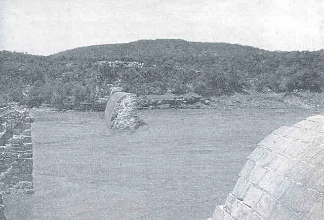
A second Austin Dam attempt fared little better. In September 1915 floodwater destroyed its automatic crest gates, and the remains took further damage in June 1935. Meanwhile the basin kept flooding without any dam’s help. LCRA’s flood history dates major events to June 12 to 20, 1935, September 15 to October 20, 1936, and July 19 to August 14, 1938. Each one threatened river settlements, farm land, Austin utilities and transport, and each one strengthened the argument for storage upstream.
The agency that would build that storage already existed. Governor Miriam A. Ferguson signed the law creating the Lower Colorado River Authority on November 13, 1934, months before the June 1935 flood, so LCRA was not created in response to that single disaster. Flood control was the urgent motive, but drought, irrigation and rural electricity pushed the same way. Austin’s two failed dams showed a city dam could not hold the river. The answer had to sit upstream, in the canyon at Marshall Ford.
03/Marshall Ford to Mansfield
Building Mansfield Dam, First Called Marshall Ford
1937 to 1942
Ground broke on February 19, 1937, with Interior Secretary Harold Ickes on site. The dam rose in two stages, filled for two years, and changed its name before it was finished.
The dam began as Marshall Ford Dam, named for the river crossing it replaced, on a federal Bureau of Reclamation project with LCRA participation. Brown & Root built it with McKenzie Construction. Congressman James P. Buchanan and Alvin J. Wirtz had organized the federal and state backing, finishing Buchanan and Inks dams upstream in 1938. Buchanan died on February 22, 1937, three days after the groundbreaking, and Lyndon B. Johnson entered Congress afterward and pressed the work forward. Johnson championed the project; the record does not make him its sole creator.
Crews built a low dam first, finished in the summer of 1939, then started the high dam enlargement that September. The July 1938 flood, which hit while Buchanan and Inks were new, sharpened the case for the taller structure. First mass concrete had gone in on October 30, 1937. Deliberate impoundment behind the rising dam began in September 1940, and the first generating unit produced power on January 27, 1941. The lake was storing water and making electricity more than a year before the dam was done.
In 1941 the name Mansfield Dam was adopted locally for U.S. Representative Joseph Jefferson Mansfield, who had carried its cause in Congress, though federal officials still considered the change unofficial in 1949. The Bureau of Reclamation placed the last concrete in December 1941. LCRA now lists the dam as completed in 1942, built from 1937 to 1942, and federal engineering records run final cleanup, grouting and road work to May 1942. The conservation pool first filled in September 1942, about two years after impoundment began.
Why the sources give two completion dates
The 1941 and 1942 dates describe different milestones, not a simple error. The year 1941 matches the last concrete, the start of power generation and the local adoption of the Mansfield name. LCRA now lists the dam as completed in 1942, built from 1937 to 1942, as do the Texas Water Development Board and the Army Corps, which list May 1942 for the finished high dam. This page gives the milestone whenever a single date matters, and otherwise says the dam was built in stages from 1937 to 1942.
04/What the water covered
What Is Under Lake Travis: Farms, Fords and Mills
1940 to 1942
The reservoir covered about half of Hudson Bend, part of Volente, three river fords and a mill site. No intact underwater town has been verified under Lake Travis.
1940 to 1942
Hudson Bend took the deepest loss. The Handbook of Texas and its historical marker put about half of the roughly 4,000 acre bend under water, while the community survived and rebuilt along the new shoreline. In 1938 the county began condemnation of the original Hudson Bend Cemetery, and burials were reinterred at higher ground such as Teck Cemetery. County researchers warn that some unmarked burials may still remain below. That is a documented possibility, not a counted total, and no verified count of moved graves or cemeteries exists.
Volente lost only part of its ground. Families who stayed moved higher, and the settlement answered to the name Dodd City through the 1940s and into the early 1950s before Volente returned. On Cypress Creek, Thomas Anderson’s mill had already fallen to ruin before impoundment. Its original site is generally under water and, by the mill museum’s account, shows again when the lake falls below about 660 feet. The white mill visitors see today is a 1964 replica on high ground, not the rescued original.
County research also maps the drowned crossings: Marshall, Lohman and Sylvester fords, the 1931 Lohman’s bridge, and James Carlton’s largely flooded 200 acre farm on Sandy Creek. A house and cattle dipping vat at the Pearson place near Point Venture were hauled uphill ahead of the water. Divers and drought walkers still trade stories of a whole town below, but researchers have found no primary evidence for one. Old Bluffton, often named in those stories, lies under Lake Buchanan, not Lake Travis.
05/Record highs and floodgates
Lake Travis Record High: The Christmas Flood of 1991
1952 to 2018
On Christmas Day 1991 Lake Travis hit 710.44 feet, the highest level ever observed here: 29 feet above full pool, with five Mansfield floodgates open.
The Christmas flood of 1991 remains the operator’s record. LCRA lists the crest at 710.44 feet on December 25, 1991, and the monthly archive for December 1991 tops out at the same figure. That is 29.44 feet above the 681 foot top of conservation storage and 3.56 feet below the 714 foot overflow spillway elevation. LCRA’s event table credits five floodgates at Mansfield Dam during the flood. The dam crest itself sits at 750 feet, far above any observed lake surface.
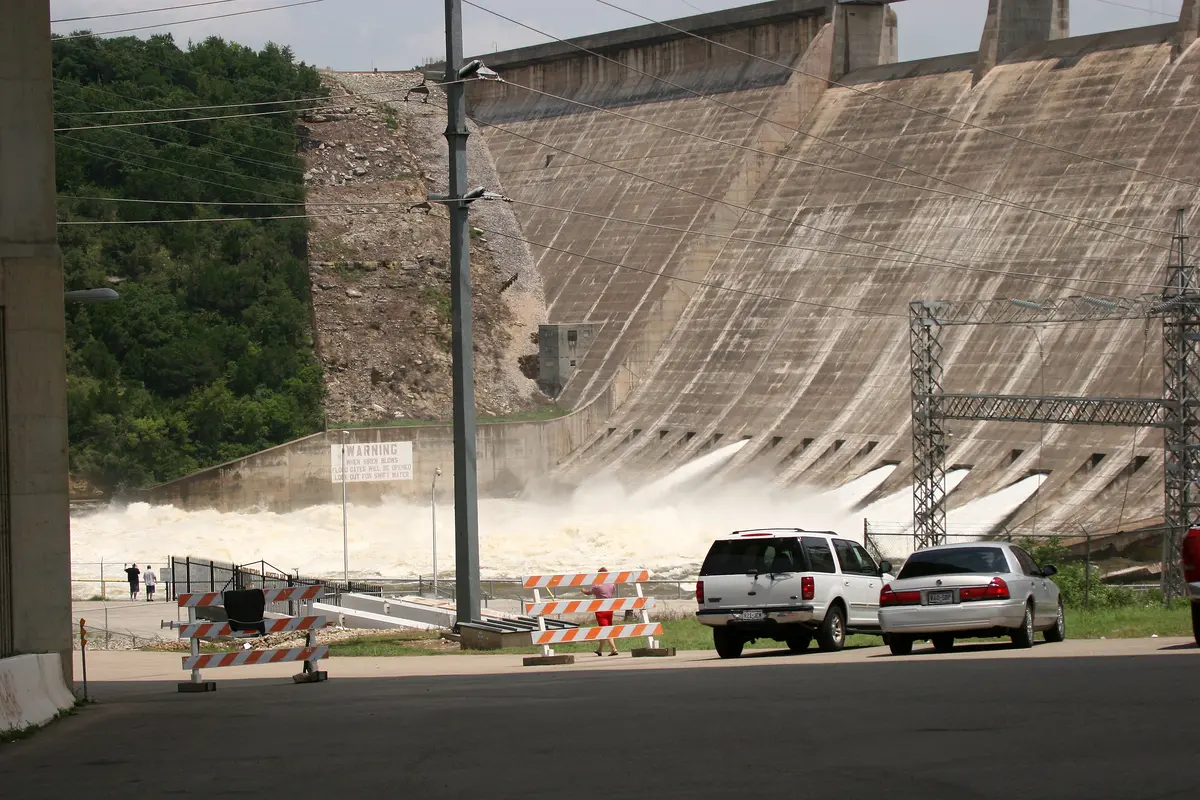
The lake had rehearsed the act. In September 1952, mid drought, inflows shoved Travis up roughly 56 to 57 feet in less than a day; LCRA and the Army Corps report slightly different windows, and the water still stopped below full pool, so no floodgates opened. In May 1957 the lake reached 707.38 feet on May 18, and operators opened six floodgates, the first operational floodgate use LCRA records for the finished dam. That 1957 crest is still the second highest monthly maximum in the archive.
Later floods filled out the top ten. The lake hit 705.11 feet on June 26, 1997, with four gates open, and 701.52 feet in July 2007, also with four gates, when recreation areas closed for 17 days. In October 2018 Llano River flooding drove the lake to 704.39 feet on October 20. Four gates stood open on October 18; eight had been announced as a plan, not achieved. Mansfield is the only Highland Lake built with dedicated flood storage, about 776,000 acre feet above full pool, and these are the floods that used it.
06/Record lows and dry years
Lake Travis Record Low: Droughts That Emptied the Lake
1951 to today
On August 14, 1951, Lake Travis fell to 614.18 feet, its lowest observed level. Drought, not flood, has defined most of the lake’s hard years since.
The record low came early. During the long Texas drought LCRA groups under 1947 to 1957, Travis bottomed at 614.18 feet on August 14, 1951, and the August archive minimum matches that figure to the hundredth. Set against the 1991 record high, the lake’s observed swing spans 96.26 feet of elevation. The September 1952 flood briefly refilled the lake, but it interrupted the drought rather than ending it. The region’s dry years finally broke with the floods of 1957.
Later droughts cut deep without reaching 1951. The lake fell to 615.02 feet on November 8, 1963, and to 636.58 feet on October 7, 1984. In 2011 inflows to the Highland Lakes totaled 127,699 acre feet, about 10 percent of the historical average and the lowest LCRA had then recorded. Travis reached 618.56 feet on September 20, 2013, the third distinct drought low in LCRA’s table. Read the full dry year sequence on the drought page.
Low water writes its own shoreline history. The original Anderson Mill site reappears below about 660 feet, and exposed stumps and debris settle into hazards for the next high water. In August 2009 a contemporary report counted the last public boat ramp on Lake Travis closed, weeks before that year’s archive low of 629.74 feet in October. Water planners use a different yardstick: the 2020 plan models October 2007 to April 2015 as its critical drought, while the 1950s still hold the lowest level ever observed.
The 2011 to 2015 drought and the slow recovery
The 2011 to 2015 drought squeezed the whole Colorado basin. LCRA curtailed interruptible agricultural water for four straight years through 2015, though contracts and exceptions meant curtailment was not the same as zero water for every farm. The January 2015 monthly minimum in the archive was 623.27 feet, and the lake then recovered substantially that year with no Mansfield flood releases at all. Recovery, like decline, arrived on the basin’s schedule rather than Austin’s rainfall.
07/Parks, marinas and resorts
How Lake Travis Became a Place to Swim, Sail and Stay
1940s to today
Within a decade of filling, shoreline colonies, marinas and lodges replaced farm work at Hudson Bend. The flood control lake had become Austin’s summer address.
1940s to today
The change showed first at Hudson Bend. Through the 1940s the surviving shore filled with colonies, lodges, boat businesses and marinas, and the farm and ranch economy gave way to weekends. Volente shifted the same way after its move uphill. No source verifies a single first marina on Lake Travis, and this page does not crown one. What the record shows instead is a fast, broad conversion: by the time the dam was a decade old, the new shoreline was a recreation economy.
County parks anchored the public shore. Mansfield Dam Park opened in 1964 on leased LCRA land beside the dam. At Pace Bend, the old Paleface Park ranch land with about nine miles of shoreline came under county lease in 1976 and county designation in 1978. Hippie Hollow, the former McGregor Park known for nude recreation since the 1960s, was leased by the county in 1983 and reopened improved in 1985. County archives call it Texas’ only clothing optional public park.
Resorts turned visits into addresses. The Lakeway Inn opened on July 12, 1963, on former Josey ranch land, with a marina, golf and an airfield behind it; Lakeway incorporated in June 1974. Point Venture’s developers organized on August 8, 1969, around a marina and country club plan. Beau Theriot opened the Oasis restaurant in 1982; fire damaged it on June 1, 2005, and it rebuilt larger. Plan a day on the water with the recreation guide.
08/Water supply and flood control
Lake Travis Today: Water Supply for the Highland Lakes
Today
Travis and Buchanan store the water. The other Highland Lakes pass it through. More than 1.4 million people in the lower basin depend on how that system is run.
The six LCRA lakes run Buchanan, Inks, LBJ, Marble Falls, Travis and Austin, in that order down the Colorado. Buchanan and Travis are the two big fluctuating storage reservoirs; the lakes between and below them hold steadier levels and pass water through. Only Travis carries a dedicated flood pool, about 776,000 acre feet between the 681 foot conservation top and the 714 foot spillway elevation. The Army Corps directs regulation inside that flood pool, while LCRA runs the dam and manages the water supply storage below it.
The numbers that govern the lake are system numbers. The approved 2020 Water Management Plan sets combined firm yield for Buchanan and Travis together at 418,848 acre feet per year, the modeled supply the pair can sustain through the plan’s critical drought. LCRA says its lower basin supply role serves more than 1.4 million people, and Austin Water draws its drinking water from the Colorado through lakes Travis and Austin. One caution travels with every figure here: 681.6 feet in the newer NAVD88 datum is the same surface as 681.0 in the dam’s legacy datum.
The old swing continues. Hill Country flooding in July 2025 lifted Travis from 637.34 feet on July 1 to 674.06 by July 17, still below full pool and with no Mansfield floodgates; LCRA later confirmed none had operated since 2019. In July 2026 LCRA announced at least two gates planned for July 18, the first since 2019, though a final operated count was not verified for this history. Follow the level now at the current level and releases at dam releases.
Key dates in the life of the lake
Twelve dates carry the story from a state law in 1934 to the floods and droughts that still set the lake’s limits.
Nov 13, 1934
Texas creates LCRA
Governor Miriam A. Ferguson signs the law creating the Lower Colorado River Authority, the agency that will build and run Mansfield Dam.
Read the chapter: River floodsFeb 19, 1937
Ground breaks at Marshall Ford
Interior Secretary Harold Ickes joins the groundbreaking for Marshall Ford Dam. First mass concrete follows on October 30, 1937.
Read the chapter: Building the dam1940 to 1941
Water rises, power flows
Deliberate impoundment begins in September 1940. The first generating unit produces power on January 27, 1941.
Read the chapter: Building the damSep 1942
The lake fills for the first time
The conservation pool first fills in September 1942, about two years after impoundment began and months after final dam work ends.
Read the chapter: Building the damAug 14, 1951
Record low in the 1950s drought
Lake Travis falls to 614.18 feet, the lowest level ever observed, during the drought LCRA groups under 1947 to 1957.
Read the chapter: DroughtsSep 1952
A 56 foot rise in under a day
Flood inflows lift the low lake roughly 56 to 57 feet in less than 24 hours. The water stays below full pool and no floodgates open.
Read the chapter: Flood recordsMay 18, 1957
First floodgates open
The lake crests at 707.38 feet and operators open six floodgates, the first operational floodgate use LCRA records at the dam.
Read the chapter: Flood recordsJul 12, 1963
Lakeway Inn opens
The Lakeway Inn opens on former Josey ranch land, marking the resort turn. Lakeway incorporates eleven years later, in June 1974.
Read the chapter: Recreation eraDec 25, 1991
Christmas flood sets the record high
Lake Travis crests at 710.44 feet, the highest level ever observed, with five Mansfield floodgates open.
Read the chapter: Flood recordsAug 2009
Last public boat ramp closes
Drought closes the last public boat ramp on Lake Travis weeks before the lake reaches its October 2009 low of 629.74 feet.
Read the chapter: DroughtsSep 20, 2013
Third great drought low
The lake falls to 618.56 feet after the driest inflows in LCRA records, the third distinct drought low in the operator table.
Read the chapter: DroughtsOct 20, 2018
Llano flood drives the lake up
Llano River flooding crests Travis at 704.39 feet. Four gates stand open on October 18; eight had been announced as a plan.
Read the chapter: Flood records
Questions about the history of Lake Travis
Short answers to the questions readers ask most about how the lake was made and what its records are.
Is Lake Travis man-made?
Yes. Lake Travis is an artificial reservoir on the Texas Colorado River, created by Mansfield Dam northwest of Austin. LCRA operates the dam, and the lake stores water supply below 681 feet and floodwater above it. No natural lake of this size existed in the canyon before the dam. The river valley held farms, fords and a mill site instead.
When was Lake Travis built?
Mansfield Dam, first called Marshall Ford Dam, was built in stages from 1937 to 1942. Ground broke on February 19, 1937, deliberate impoundment began in September 1940, and power generation started on January 27, 1941. The last concrete was placed in December 1941. LCRA now lists completion in 1942, federal records end final work in May 1942, and the pool first filled that September.
Why is it called Lake Travis?
By most accounts the lake takes its name from William B. Travis, the Alamo commander, as Travis County itself does. The county namesake is documented, but researchers for this page found no surviving instrument that names the lake directly. So the Travis connection is the standard explanation, reported here with that qualification rather than as a proven naming act.
What is under Lake Travis? Are there towns below?
Parts of Hudson Bend and Volente, three river fords, the 1931 Lohman bridge site and the original Anderson Mill site lie under Lake Travis. Families moved uphill, and Hudson Bend burials were reinterred at higher cemeteries from 1938. No intact underwater town has been verified. Old Bluffton, often cited in lake lore, is under Lake Buchanan, a different reservoir upstream.
What is the highest Lake Travis has ever been?
The highest observed level is 710.44 feet on December 25, 1991, during the Christmas flood. LCRA lists that crest, the December 1991 monthly archive confirms it, and five Mansfield floodgates were open. The crest stood 29.44 feet above the 681 foot full pool and 3.56 feet below the 714 foot overflow spillway elevation.
What is the lowest Lake Travis has ever been?
The lowest observed level is 614.18 feet on August 14, 1951, during the 1950s drought. LCRA lists the date and the August 1951 archive minimum matches it. Later droughts came close without passing it: 615.02 feet in November 1963 and 618.56 feet in September 2013. The full observed swing, low to high, spans 96.26 feet.
How deep is Lake Travis?
Texas Parks and Wildlife lists a maximum depth of 190 feet for Lake Travis. Depth depends on the lake level, so the deepest water shrinks as the surface falls from the 681 foot full pool. A widely repeated 210 foot figure appears in secondary sources. This page uses the attributed TPWD figure and does not claim a surveyed deepest point location.
Why is 681 feet the full level for Lake Travis?
681 feet is the top of conservation storage, the water supply pool LCRA manages for cities, industry and farms. Water above 681 feet occupies the dedicated flood pool, which reaches to the 714 foot spillway elevation under Army Corps flood rules. So a lake at 681 feet is full for supply, with flood storage still empty above it.
Sources
Every fact on this page traces to the operator, engineering and public records below, checked against the LCRA monthly archive.
- [1]Dams and Lakes · Lower Colorado River Authority
Dam dimensions, pool elevations, and selected record high and low dates.
- [2]Lake Travis historical workbook (monthly elevations) · Lower Colorado River Authority
Source of every monthly level on the chart.
- [3]Mansfield (Marshall Ford) Dam and Lake Travis Water Control Manual · U.S. Army Corps of Engineers, 2013
Construction chronology, flood history, datum conversions and flood pool duties.
- [4]Colorado River Project history · Bureau of Reclamation, 2000
Federal project history of construction, funding and the Mansfield naming.
- [5]Lake Travis, Colorado River Basin · Texas Water Development Board
Engineering chronology and survey based reservoir figures.
- [6]Enhancing Texan lives: the birth of LCRA · Lower Colorado River Authority
Founding of LCRA on November 13, 1934, and the first Colorado River dams.
- [7]2007 Flood Report · Lower Colorado River Authority, 2007
Historical flood event table, gate counts and crest dates through 2007.
- [8]Travis County · Texas State Historical Association
County geography and early occupation of the river valley.
- [9]Hudson Bend, Texas · Texas State Historical Association
Settlement, inundation and the shoreline colony era at Hudson Bend.
- [10]
- [11]Northwestern Travis County historic context report · Travis County Historical Commission
Settlements, river crossings and land covered by the reservoir.
- [12]Finding the original Hudson Bend Cemetery · Travis County Historical Commission, 2024
1938 condemnation and reinterment records for Hudson Bend Cemetery.
- [13]Travis County park histories: Pace Bend, Hippie Hollow, Mansfield Dam and Windy Point · Travis County Archives
County park dates for Pace Bend, Hippie Hollow and Mansfield Dam Park.
- [14]Mill history · Anderson Mill Museum
Original Cypress Creek mill site, its exposure at low water and the 1964 replica.
- [15]Lakeway anniversaries and history · City of Lakeway
Lakeway Inn opening on July 12, 1963, and incorporation in June 1974.
- [16]Point Venture history · Point Venture Property Owners Association
Development company formation on August 8, 1969, and resort plans.
- [17]Lake Travis fisheries profile · Texas Parks and Wildlife Department
Published 190 foot maximum depth for the lake.
- [18]The Highland Lakes are almost full again: now what? · Lower Colorado River Authority, 2025
Flood storage role of Travis and the September 2025 gate operations statement.
- [19]2020 Water Management Plan · Lower Colorado River Authority, 2020
Combined Buchanan and Travis firm yield of 418,848 acre feet per year.
- [20]2012 Basin Summary Report · Lower Colorado River Authority, 2012
Record low Highland Lakes inflows of 127,699 acre feet in 2011.
- [21]2024 Drinking Water Quality Report · Austin Water, 2024
Colorado River through lakes Travis and Austin as drinking water source.
- [22]Austin Energy history timeline · Austin Energy
First Austin Dam of 1893, its 1900 failure and later dam attempts.
- [23]LCRA to begin floodgate operations at Mansfield Dam · Lower Colorado River Authority, 2026
Announced July 2026 gate operations, the first planned since 2019.